
Thermal Drone Surveys Supporting Ecological Assessments
The Challenge
MRF was engaged to support ecologists and ornithologists in undertaking nesting bird inspections across extensive areas of steep and difficult terrain, including heavily vegetated embankments, dangerous drops and areas adjacent to open water.
Accessing many of these locations on foot was physically demanding and, in certain areas, presented potential safety risks to survey teams. The size of the site and the dense vegetation also made traditional survey methods both time consuming and challenging to undertake efficiently across the entire area.
The primary challenge was therefore to assist the ecological teams by providing an additional method of identifying potential nesting locations and areas of interest, enabling survey efforts to be more effectively targeted whilst improving site understanding and reducing unnecessary access into difficult and potentially hazardous areas.
Our Solution
Working alongside a highly experienced ornithologist, MRF developed and implemented a thermal survey procedure specifically aimed at supporting nesting bird inspections.
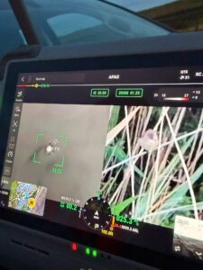
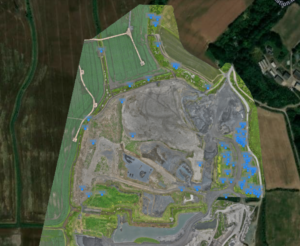
Utilising our in-house thermal drone platform, early morning flights were undertaken to identify thermal anomalies and potential areas of interest across the site. Any potential nesting locations or points of ecological interest identified during the surveys were accurately georeferenced, with GPS pin locations recorded and provided directly to the ornithological team.
This approach enabled the ornithologists to focus their early morning inspections on specific areas of interest, significantly improving the efficiency of the survey process and reducing the amount of time required to search large areas of difficult terrain.
The combination of thermal imagery, accurate GPS positioning and experienced ecological interpretation provided an additional layer of intelligence to support traditional nesting bird surveys, whilst also reducing the need for unnecessary access into steep, heavily vegetated and potentially hazardous areas.
Project Benefits
✓ Improved safety by reducing the need to access hazardous terrain.
✓ Faster identification of potential nesting locations across large areas.
✓ More targeted surveys, allowing ornithologists to focus efforts on specific areas of interest.
✓ Early identification of ecological constraints, improving project planning and reducing programme risk.
Project Images
Looking Ahead
The successful implementation of thermal drone technology on this project has demonstrated the value of combining innovative survey techniques with experienced ecological expertise.
MRF will continue to develop and refine these methodologies, working alongside ecologists and ornithologists to provide safer, more efficient and data-driven solutions for complex projects.
As the technology evolves, thermal surveys will continue to play an important supporting role in helping project teams better understand ecological constraints at an early stage, improving planning, reducing programme risk and enhancing environmental outcomes.
P.S. Thermal imaging provides an additional layer of intelligence to support ecological surveys and is always used alongside traditional survey methods and professional ecological judgement.
Need support with your project?
MRF Contracting provides specialist vegetation management, drone surveys, ecological support, enabling works and infrastructure services throughout the UK.
 office@mrfcontracting.comThermal Drone Surveys Supporting Ecological Assessments